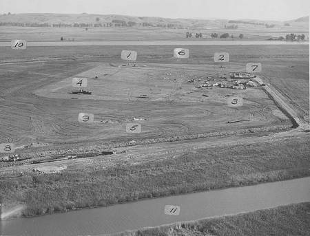
Wow! Here is a great picture. This is an aerial shot of the KCBS transmitter site taken on November 3, 1950. Instead of my trying to explain it, I found the original description for this photo and will include it here.
The view is in a generally eastward direction. In the background at #10 is the Petaluma Creek, a tidewater arm of San Francisco Bay. It is navigable for small commercial craft, barges, etc., as far as the town of Petaluma, about eight miles to the north.
In the foreground at #11 is Black John Slough, a small tributary of Petaluma Creek. Their relative sizes are distorted by the angle at which the picture was taken. Actually, Petaluma Creek is very much the larger of the two.
#1-2-3-4 are tower foundations. A truck is delivering tower steel at tower #4.
Along a line between #5 and #6 may be seen the 4 dual guy wire anchors. The single anchors which lie to the right and left are not clearly visible in the picture.
At #7 is the transmitter building which has progressed as far as the floor form. The intricate system of electrical conduits, wiring troughs and reinforcing steel is in place and concrete for the floor will be poured on November the 13th. Close to the building are the small construction offices and parked cars of the workmen.
The filled and rock surfaced road from the levee in the foreground to the building is shown complete except for final surfacing.
At #8 a group of men are working on the foundation of the 9000 gallon per minute drainage pump, which will lift water from the drainage ditch over the levee into Black John Slough.
Extending in aline from #8 past #9 cover to the building site are two conduits buried about 5 feet underground. One will carry the telephone cable for program and telephone service and the other will carry the 12,000 volt cable which furnishes power for the transmitter. The underground ducts are in place and covered except at the access holes left at intervals. After the wire has been pulled through the duct these will also be covered. It was necessary that these ducts be placed so that the land around the lease area could be ploughed for farming purposes. The lease are which is un-ploughed shows clearly in the picture.
There is considerable fore shortening in an angle shot of this kind which makes it difficult to appreciate actual distances. For instance, it is 660 feet from tower #1 to Tower #4 and 330 feet from Tower #1 to Tower #2. Each tower will be 500 feet high. If tower #4 were laid along the ground past tower #3 it would extend from it's foundation to a point about 75 feet out in the ploughed area to the right of the road.
Questions or comments about the tour?
![]()
Updated 12/8/98
KCBS-KLLC ENGINEERING DEPT